skip to main | skip to sidebar

Satelite Image


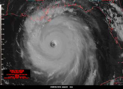
WOW!! I thought this picture was amazing this is hurricane Katrina south of Louisianna. The center of the storm looks so neat and perfect. It is hard to beleive that something that looks so beautiful from above as it does in this satalite image can cause such destruction on the land. This is something that no one wants to see coming toward them.

No comments:

Post a Comment

Newer Post Older Post Home
Subscribe to: Post Comments (Atom)

SuperNova

Blog Archive

  • ▼  2008 (50)
    • ▼  August (45)
      • Papyrus
      • Cave drawings
      • Isotherm
      • A Lorenz curve is used to rpresent some sort of pr...
      • stem and leaf plot
      • cartographic animation
      • Stastistical
      • Black and white aerial photo
      • Political
      • Unclassed Choropleth
      • Nominal Area Choropleth
      • Proportional Circle Map
      • cartogram
      • DOQ
      • Digital Raster Graphic
      • Isoline
      • Isopleth
      • Isohyet
      • geologic map
      • Isotachs
      • Satelite Image
      • Histogram
      • Triangular Plot
      • Scatter Plot
      • Stick Map
      • Choropleth Map
      • Flow Map
      • Contour Maps
      • Dot Distribution
      • Hyposomentric
      • Climograph
      • Population Profile
      • Isobars
      • Infrared
      • Mental Map
      • LIDAR
      • DEM
      • Planimetric Map
      • Thematic Map
      • Aerial Photograph
      • WindRose
      • Shaded Releef Map
      • Propoganda
      • Box Plot
      • Star plot
    • ►  June (5)

About Me

Kristin
View my complete profile
 

Labels

  • Map Catalog (8)
  • Week 7 Assignment (2)